GIS SERVICE PACKAGES
EIA / BA Map Package
- Locality Map
- Site Layout Map
- Alternatives Map
- Sensitivity / Constraints Map
- CBA Map
- Protected Areas Map
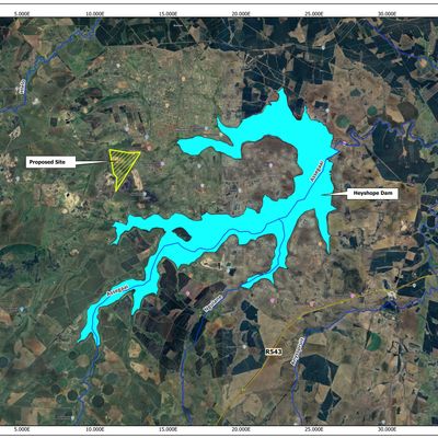
- Hydology
- Geology
- Vegetation
- Ecosystem
- Municipality, Wards, and provincial
- Final DFFE Layout with all the recommended buffers
Packages are tailored to project requirements.
WATER USE LICENCE /IWWMP GIS PACKAGES
- Master Plan
- Locality and regional context maps
- Site layout and infrastructure maps
- Water use activity mapping (Section 21 activities)
- Wetland, river, and drainage line mapping
- Catchment and sub-catchment maps
Packages are tailored to project requirements.
Mining Application GIS Package
- Locality Map
- Mining Area Map
- Environmental Constraints Map
Compliance Map Revision Package
- Review of existing maps
- Authority comment response mapping
- Updated final submission maps